A shortwave trough with a fairly strong piece of shortwave pushing east through the Great Lakes during the day tomorrow will allow for a pre-frontal trough and cold front to push east as well approaching southern New England late tomorrow evening. Out ahead of the front a hot and extremely humid airmass will overspread the region with temperatures ranging from the mid-80's to the lower 90's and dewpoints into the lower 70's. The combination of high heat/humidity will allow for an extremely unstable airmass to develop during the late morning and afternoon hours.
While typically we see the possibility of strong to severe t'storms decrease with the loss of daytime heating as this allows the atmosphere to stabilize, that won't be the case this time. Computer forecast models have been rather consistent in an area of steep mid-level lapse rates associated with an elevated mixed-layer plume moving overhead on Sunday. With the presence of steep mid-level lapse rates, combined with the hot/humid airmass, the atmosphere will remain quite unstable through the evening and into the overnight hours.
Below is the 18z run of the GFS from 7/18/15 showing surfaced-based cape values as high as 1500 J/KG valid for 11:00 PM Sunday evening:
Associated with the approaching shortwave trough will also be some pretty strong wind shear aloft. Computer forecast models overspread as much as 40-50 knots of surface-500mb bulk shear values between 11:00 PM Sunday evening and 2:00 AM Monday morning:
With such an unstable airmass in place, strep lapse rates, increasing shear, and a source for lift, we will see showers and t'storms develop and move into the region during the evening hours tomorrow and lasting through the overnight. A few of these storms will have the potential to become rather strong to severe and pose a threat for large hail and damaging winds. In addition, storms will contain torrential downpours and vivid lightning.
The degree of the severe potential is still a bit in question as there are some uncertainties with regards to timing of all the features and whether or not all the best parameters align together. The NAM computer forecast model also develops a quite a bit of activity during the afternoon on Sunday just off to our west and across New England and this would weaken lapse rates aloft reducing the severe threat after sunset. Given how the atmosphere should be capped pretty well during the afternoon this scenario doesn't seem all that likely at this time.
The timeframe for t'storms and severe potential should be from 7:00 PM Sunday evening lasting through 3:00 to 4:00 AM Monday. A second threat for strong to severe t'storms may be possible later Monday morning and early afternoon across southeastern New England as the cold front pushes through.
Saturday, July 18, 2015
Sunday, June 28, 2015
Wednesday, July 1st, 2015 storm potential
A potent trough and attendant shortwave will slowly be pushing eastward during the day on Wednesday allowing for a cold front to also slowly push east. Ahead of the trough the surface and low-level flow will be out of the southwest allowing for a warm and moist low-level airmass to set in place.
As the shortwave moves just to our north it will be associated with some pretty cold temperatures in the mid-levels of the atmosphere for this time of year. The GFS computer forecast model suggests temps at 700mb (~10,000ft ASL) as cold as +4 to +6C with temps at 500mb (~18,000ft ASL) between -10C and -12C and perhaps as cold as -12C to -14C. This should yield to some fairly steep mid-level lapse rates (change of temperature with height).
With surface temperatures projected to warm into the lower 80's and dewpoints expected to climb into the mid to perhaps upper 60's, the combination of warm temps, high dews, and presence of steep lapse rates should yield to a modestly unstable airmass to develop in the afternoon/evening hours.
There will also be some decent wind shear associated with the trough with winds a few thousand feet up off the ground as strong as 25-35 knots with winds around 10,000ft as strong as 30-40 knots and winds around 18,000ft as strong as 40-45 knots.
What all these ingredients point to is the potential for showers and thunderstorms to develop and perhaps become quite numerous as the afternoon progresses. While typically we see the threat for showers and t'storms diminish as the sun begins to set, colder air working in the mid-levels of the atmosphere may keep activity going well through the evening hours. Given the degree of winds aloft and such cold mid-level temperatures leading to low freezing levels, the strongest t'storms will be capable of producing hail and strong winds. Even coastal areas will have the potential despite a sea-breeze. Typically in these setups the sea-breeze is a non-factor and if anything can sometimes act as an enhancer. All t'storms will also produce torrential downpours given degree of low-level moisture.
One thing to watch, however, is the potential for some rising heights across portions of southern New England later in the afternoon into the evening. The GFS forecast model shows heights rising a bit later in the afternoon. If this occurs this could diminish activity as the afternoon progresses or prevent further activity developing.
As the shortwave moves just to our north it will be associated with some pretty cold temperatures in the mid-levels of the atmosphere for this time of year. The GFS computer forecast model suggests temps at 700mb (~10,000ft ASL) as cold as +4 to +6C with temps at 500mb (~18,000ft ASL) between -10C and -12C and perhaps as cold as -12C to -14C. This should yield to some fairly steep mid-level lapse rates (change of temperature with height).
With surface temperatures projected to warm into the lower 80's and dewpoints expected to climb into the mid to perhaps upper 60's, the combination of warm temps, high dews, and presence of steep lapse rates should yield to a modestly unstable airmass to develop in the afternoon/evening hours.
There will also be some decent wind shear associated with the trough with winds a few thousand feet up off the ground as strong as 25-35 knots with winds around 10,000ft as strong as 30-40 knots and winds around 18,000ft as strong as 40-45 knots.
What all these ingredients point to is the potential for showers and thunderstorms to develop and perhaps become quite numerous as the afternoon progresses. While typically we see the threat for showers and t'storms diminish as the sun begins to set, colder air working in the mid-levels of the atmosphere may keep activity going well through the evening hours. Given the degree of winds aloft and such cold mid-level temperatures leading to low freezing levels, the strongest t'storms will be capable of producing hail and strong winds. Even coastal areas will have the potential despite a sea-breeze. Typically in these setups the sea-breeze is a non-factor and if anything can sometimes act as an enhancer. All t'storms will also produce torrential downpours given degree of low-level moisture.
One thing to watch, however, is the potential for some rising heights across portions of southern New England later in the afternoon into the evening. The GFS forecast model shows heights rising a bit later in the afternoon. If this occurs this could diminish activity as the afternoon progresses or prevent further activity developing.
Tuesday, June 23, 2015
Noon severe weather update
Showers and some embedded thunderstorms pushed through portions of New England this morning, particularly along and north of Windsor Locks, CT. While clouds are still in place, satellite trends have been breaking up the clouds west of southern New England and the sun has been in and out. Given recent satellite trends, more and more breaks of sun should occur across much of MA and south into CT and RI.
The combination of steep mid-level lapse rates, in excess of 6.5 C/KM, rich low-level moisture characterized by dewpoints climbing into the lower 70's, and surface temps rising into the 80's will all lead to quite an unstable airmass this afternoon. It's still a bit unclear as to how unstable we become due to the presence of clouds but some areas could end up with over 1500-2500 J/KG of Cape...which would be quite significant given the degree of wind shear aloft.
Some of the latest computer forecast models, more particularly the higher resolution models, develop what appears to be a broken line of supercells moving through MA and CT later this afternoon. At this time the potential for severe weather is still certainly in place along with the possibility for some significant severe weather including damaging wind gusts in excess of 70 mph, hail as large as golf balls, and a few isolated tornadoes. A strong tornado can't be ruled out either.
The best timeframe appears to be between 2-6 PM (as late as 8 PM for RI and SE MA if activity sustains) for strong to severe t'storms capable of the hazards described above.
The situation will continue being monitored with updates provided as needed.
Below is the latest satellite image from noon showing breaks of clouds moving east:
Update on today's severe potential
Forecasting severe weather across New England can be quite challenging at times...in fact it can be challenging most of the time. There are just so many mesoscale factors and features that need to come together perfectly and you really need to just watch things evolve pretty much as they are. This situation is no different.
For the past few days computer forecast guidance has really been hammering the potential for a significant severe weather event to occur across portions of New England with the potential for widespread damaging winds, large hail, and even a few tornadoes all possible. They key to realizing the highest potential is to get all the main ingredients to fall in place at the same time.
While all these hazards are still on the table, as the morning progresses confidence has decreased a bit and confidence is on the lower side as to exactly what will happen today and exactly how big the event will be.
Currently there is a large complex of t'storms just to the west of New England called a mesoscale convective complex (MCS) that is racing towards CT/MA/VT/NH. This complex is associated with a great deal of cloud debris and if this complex does not fall apart quickly that could vastly reduce the degree of solar heating we achieve today which means less in the way of instability. It could also mean for an earlier show of action which also means less instability and less potential for a major severe weather event.
While some early indications projected areas along and north of the MA Pike for the highest severe weather potential, this area may have shifted southward to the MA Pike including interior NE MA, and down into northern CT and northwestern RI.
Here are a few scenarios which are still on the table for today
1) If the complex of t'storms to the west erodes soon and clouds begin to break up this would allow stronger surface heating to occur over New England. Given the atmospheric environment that will be in place, this scenario would be the most likely to produce a major severe weather event with damaging winds which could be as strong as 70 mph in the strongest storms, large hail of golf ball or even bigger in the strongest storms, and perhaps even a few tornadoes. In this scenario a strong tornado couldn't be ruled out somewhere.
2) If the complex of t'storms to the west does not weaken much and thicker cloud cover remains, the degree of surface heating will be much lessened across New England and the degree of instability will be much less. This will mean a reduced threat for a major severe weather event and while some strong to severe t'storms will still be possible the threat would be much more isolated. Some pockets of damaging winds would be possible, along with hail up to quarters, and still perhaps a tornado.
3) The MCS weakens as it moves into New England but comes through prior to peak heating. In this scenario the severe threat is vastly reduce. A few strong gusts perhaps knocking down weakened trees would be possible and small hail. The threat for a tornado would be very small.
At this juncture the next few hours are very crucial and all we can do is watch current radar and satellite trends along with latest hourly computer data observations and go from there. It's important to keep an eye and ear to the skies along with all the latest forecasts and updates.
For the past few days computer forecast guidance has really been hammering the potential for a significant severe weather event to occur across portions of New England with the potential for widespread damaging winds, large hail, and even a few tornadoes all possible. They key to realizing the highest potential is to get all the main ingredients to fall in place at the same time.
While all these hazards are still on the table, as the morning progresses confidence has decreased a bit and confidence is on the lower side as to exactly what will happen today and exactly how big the event will be.
Currently there is a large complex of t'storms just to the west of New England called a mesoscale convective complex (MCS) that is racing towards CT/MA/VT/NH. This complex is associated with a great deal of cloud debris and if this complex does not fall apart quickly that could vastly reduce the degree of solar heating we achieve today which means less in the way of instability. It could also mean for an earlier show of action which also means less instability and less potential for a major severe weather event.
While some early indications projected areas along and north of the MA Pike for the highest severe weather potential, this area may have shifted southward to the MA Pike including interior NE MA, and down into northern CT and northwestern RI.
Here are a few scenarios which are still on the table for today
1) If the complex of t'storms to the west erodes soon and clouds begin to break up this would allow stronger surface heating to occur over New England. Given the atmospheric environment that will be in place, this scenario would be the most likely to produce a major severe weather event with damaging winds which could be as strong as 70 mph in the strongest storms, large hail of golf ball or even bigger in the strongest storms, and perhaps even a few tornadoes. In this scenario a strong tornado couldn't be ruled out somewhere.
2) If the complex of t'storms to the west does not weaken much and thicker cloud cover remains, the degree of surface heating will be much lessened across New England and the degree of instability will be much less. This will mean a reduced threat for a major severe weather event and while some strong to severe t'storms will still be possible the threat would be much more isolated. Some pockets of damaging winds would be possible, along with hail up to quarters, and still perhaps a tornado.
3) The MCS weakens as it moves into New England but comes through prior to peak heating. In this scenario the severe threat is vastly reduce. A few strong gusts perhaps knocking down weakened trees would be possible and small hail. The threat for a tornado would be very small.
At this juncture the next few hours are very crucial and all we can do is watch current radar and satellite trends along with latest hourly computer data observations and go from there. It's important to keep an eye and ear to the skies along with all the latest forecasts and updates.
Saturday, June 20, 2015
Strong to Severe T'storms Possible Tuesday 6/23/2015
Several pieces of computer forecast guidance are showing the potential for showers and t'storms across the region during the afternoon and evening hours on Tuesday. Several atmospheric ingredients may move in place and move together to allow for the potential for some very potent thunderstorms posing a threat for strong to damaging winds, large hail, and perhaps even a few tornadoes.
Typically setups like this are on the rare side, however, what is opening some eyes with this setup is the potential advection of an elevated mixed-layer plume working in from out west. For more on elevated mixed-layers, their origin, and importance in higher-end severe weather events please read this more detailed information provided here:
http://weatherwiz.blogspot.com/2015/06/what-is-elevated-mixed-layer.html
To explain EML's as simply as possible, they are capping inversions which prevent clouds, showers, and thunderstorms from developing too early and this allows for stronger heating and can lead to extreme amounts of instability developing below the capping inversion depending on how high the temperatures are and how high the dewpoints are.
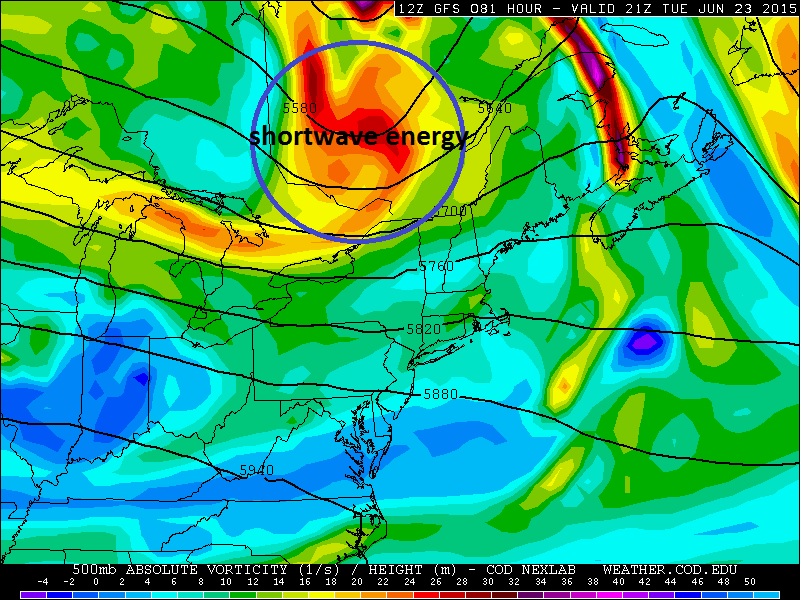
Computer forecast models are showing a very strong piece of shortwave energy passing just to the north of the US/Canadien border. This track may favor the greatest risk of severe storms being further north across New England, (central/northern MA into portions of VT/NH and into ME so the track of the s/w will have to be watched closely:
Computer forecast guidance also develops some extreme instability across the region with Cape perhaps as high as 2500-3000 J/KG and very strong wind shear, both speed shear (increase of winds with height) and directional shear (change of wind direction with height). This combination could lead to the potential for any thunderstorms that develop to become quite severe and have the potential to produce damaging winds, large hail, and perhaps even a tornado.
Below is the 12z NAM bufkit for Windsor Locks, CT late Tuesday afternoon. This is a pretty alarming sounding with extreme instability, high shear, and very high helicity being forecasted. This is something seen more typically in the plains than here in CT.
This definitely needs to be watched!
Typically setups like this are on the rare side, however, what is opening some eyes with this setup is the potential advection of an elevated mixed-layer plume working in from out west. For more on elevated mixed-layers, their origin, and importance in higher-end severe weather events please read this more detailed information provided here:
http://weatherwiz.blogspot.com/2015/06/what-is-elevated-mixed-layer.html
To explain EML's as simply as possible, they are capping inversions which prevent clouds, showers, and thunderstorms from developing too early and this allows for stronger heating and can lead to extreme amounts of instability developing below the capping inversion depending on how high the temperatures are and how high the dewpoints are.
Computer forecast models are showing a very strong piece of shortwave energy passing just to the north of the US/Canadien border. This track may favor the greatest risk of severe storms being further north across New England, (central/northern MA into portions of VT/NH and into ME so the track of the s/w will have to be watched closely:
Computer forecast guidance also develops some extreme instability across the region with Cape perhaps as high as 2500-3000 J/KG and very strong wind shear, both speed shear (increase of winds with height) and directional shear (change of wind direction with height). This combination could lead to the potential for any thunderstorms that develop to become quite severe and have the potential to produce damaging winds, large hail, and perhaps even a tornado.
Below is the 12z NAM bufkit for Windsor Locks, CT late Tuesday afternoon. This is a pretty alarming sounding with extreme instability, high shear, and very high helicity being forecasted. This is something seen more typically in the plains than here in CT.
This definitely needs to be watched!
What is an Elevated Mixed-Layer?
The origin of the EML
Importance of the EML and severe thunderstorms
The EML is also known as a capping inversion because of the warming and drying of the atmosphere where the EML begins. Remember, air will continue to rise as long as the surrounding air is cooler than the temperature of the parcel. Once the air begins to warm, this process is no longer occurring, thus the air parcel no longer rises. This process inhibits clouds, showers, and thunderstorms from developing which allows for the sun to continue shining strong. If the low level airmass is warm to hot and there is a rich presence of moisture (high dewpoints) the combination of the very steep lapse rates, high surface temps, and high dews leads to the development of extreme instability, a key ingredient in the development and strength of thunderstorms.
If some sort of lifting mechanism, such as a cold front, potent shortwave, etc, pushes in and provides enough lift to break through the cap, thunderstorms would begin to initiate and become very strong very quickly. If the capping inversion is too strong then one of two things can happen; 1) No activity develops and all the instability goes to waste or 2) Only a few storms develop. This can actually enhance the severity of the storms that develop because with only a few storms around the updrafts are not fighting each other.
How can EML's be observed?
An EML is easily observed on a skew-t forecast sounding which gives you a look at the entire atmospheric profile. Below is an example of what a true EML looks like on a forecast sounding:
In the above sounding you can see the region of extremely warm (where the black temperature line jets off to the right) and extremely dry (where the green dewpoint line shoots off to the left) air.
EML advection into the Northeast
While EML's don't often survive the journey into the Northeast, every now and then a plume of EML air can break off from the source region and ridge up over ridging at 700mb and remain in tack all the way into the Northeastern United States. However, ridging at 700mb does not always guarantee EML advection into the Northeast. In a research paper published by meteorologists Michael Ekster and Peter Bannacos, both identified 36 EML events and the corresponding 700mb pattern in place 36 hours prior to the event, 24 hours prior to the event and the observed day of the event. As you can see ridging at 700mb appears dominant across the southeastern United States extending northward into the mid-At;antic and into the Northeast:
Friday, February 13, 2015
Potent Storm System To Bring Region Wide Impacts Saturday Through Sunday
A clipper system diving southeast out of Canada is going to rapidly intensify into a very powerful storm just off the coast. This system will be will bring a slew of impacts to southern New England including; moderate to heavy snowfall, the potential for very strong damaging winds, brutally cold temperatures, and dangerous wind chills. All the latest trends indicate that the potential for the highest snowfall amounts will be confined to eastern MA once again. This system is expected to have significant impacts and we will break everything down. First, we will take a brief look into the setup:
Brief Meteorological Look
An innocent clipper system will be tracking southeast from central Canada and move right over southern New England. As this clipper system moves off-shore, rapid cyclogenesis (strengthening) is expected to occur. As the system begins to rapidly intensify, moisture will get drawn into the system and this will eventually lead to snowfall breaking out across the region. In response to the system rapidly strengthening, this will increase the pressure gradient across the region and this will yield to very strong to perhaps damaging winds developing, especially across eastern MA and the Cape area. With the wind component mainly from the north and northeast, this will reinforce brutal Arctic cold into the region with temperatures mainly in the single digits and teens throughout the duration of the storm. This coupled with the potential for very strong winds will yield to some dangerous wind chill values.
We will now do a breakdown of each associated hazard expected with this system and what we can expect with each associated hazard:
Snow
We will first look at the snowfall potential associated with this system. This will be an all snow event...no worries about any sleet, freezing rain, or rain mixing in as temperatures throughout the atmospheric column are more than supportive for snow. One thing with this system is, the precipitation really doesn't get cranking until the system is strengthening off-shore. This will lead to reduced snowfall totals the further west you go, however, the further east you go, this could yield to some significant snowfall accumulations (>12'').
During the day on Saturday we will see periods of light snow region wide, these snows will be associated with the clipper as it moves overhead towards the coast. Snowfall accumulations during the afternoon hours should be on the light side, perhaps a few inches in spots but the periods of heavier snow don't begin until we near the evening hours.
As we approach the evening hours and the clipper and energy aloft associated with the clipper begin to move off-shore, the strengthening process will rapidly begin to occur. As this happens stronger lift will develop across the region and more moisture will work into the system. This is when we will begin to see periods of moderate to heavier snowfall break out across some spots.
Due to the fact that this system will be strengthening off to our east instead of off to our southwest, this means the majority of the heaviest snows will be on the backside of the system associated with what is called the cold-conveyor belt (or CCB). It is this which will be key as to where the heaviest snowfall sets-up and where the highest snowfall totals occur. The big question with regards to the CCB is when does it begin to develop and take shape. This is something that needs to be watched, especially for CT and central MA as if this develops later as opposed to earlier it will mean reduced snowfall totals, however, if it develops earlier, that would lead to increased snowfall totals so this will be closely monitored over the next 24-hours.
We are looking at the time period from late overnight Saturday (roughly 2-3 AM) through late morning to about noon time on Sunday as the timeframe for the heaviest snows to occur. Across western and central MA down to western and central CT, snows should begin to taper off mid-Sunday AM.
Under the heaviest banding of snows, snowfall rates could approach as much as 4-5''/HR but this will not be the norm region wide...these totals will only be confined to the heaviest banding and where thundersnow is possible which is more likely to occur out across eastern MA. Elsewhere expect snowfall rates of up to 1''/HR at times.
Here are my initial snowfall projections but this will be further fine tuned tomorrow:
Wind
Wind will be a major issue with this system, especially out across eastern MA thanks to a very tight pressure gradient that will be in place with the near 970mb low just to our east. The combination of very strong winds and snow will yield to blizzard conditions at times, especially out across eastern MA and will also lead to very dangerous wind chill values. Winds out across eastern MA towards the Cape could gust upwards of 70-80 mph! These are gusts which will rival category 1 hurricane strength and would lead to widespread power outages along with big time drifting blowing and drifting of snow. As you move further west across southern New England the magnitude of the winds won't be as severe, however, we are still looking at winds gusting potentially upwards of 65 mph. These values are still strong enough to yield scattered power outages along with blowing and drifting snow. We will actually see winds becoming gusty during the day today and continue right through Monday with the peak intensity of the winds from tomorrow night through much of Sunday. If the higher end of these values are realized across eastern MA not only would we be looking at widespread power outages but outages lasting several days or longer. Here is a map showing the potential wind gusts:
Temperatures
Temperatures will be down right COLD. We are only looking at temperatures to be in the single digits to perhaps the low teens throughout the duration of this event as brutally cold Arctic air is transported southward thanks to strong northerly to northeasterly winds.
Wind Chill Values
The combination of temperatures only in the single digits to perhaps low teens and winds sustained between 20-30 mph (higher further east) with potential for gusts 60+ mph will yield very dangerous values at times. We could see wind chills range anywhere from -15F to as low as -25F during the storm. Those are very dangerous values and pose a high risk for frostbite in a very short amount of time. It is this reason, along with the accumulating snows that travel should not be done unless absolutely necessary. If you are out traveling and get caught this will pose a life threatening situation given the degree of cold we are dealing with.
Brief Meteorological Look
An innocent clipper system will be tracking southeast from central Canada and move right over southern New England. As this clipper system moves off-shore, rapid cyclogenesis (strengthening) is expected to occur. As the system begins to rapidly intensify, moisture will get drawn into the system and this will eventually lead to snowfall breaking out across the region. In response to the system rapidly strengthening, this will increase the pressure gradient across the region and this will yield to very strong to perhaps damaging winds developing, especially across eastern MA and the Cape area. With the wind component mainly from the north and northeast, this will reinforce brutal Arctic cold into the region with temperatures mainly in the single digits and teens throughout the duration of the storm. This coupled with the potential for very strong winds will yield to some dangerous wind chill values.
We will now do a breakdown of each associated hazard expected with this system and what we can expect with each associated hazard:
Snow
We will first look at the snowfall potential associated with this system. This will be an all snow event...no worries about any sleet, freezing rain, or rain mixing in as temperatures throughout the atmospheric column are more than supportive for snow. One thing with this system is, the precipitation really doesn't get cranking until the system is strengthening off-shore. This will lead to reduced snowfall totals the further west you go, however, the further east you go, this could yield to some significant snowfall accumulations (>12'').
During the day on Saturday we will see periods of light snow region wide, these snows will be associated with the clipper as it moves overhead towards the coast. Snowfall accumulations during the afternoon hours should be on the light side, perhaps a few inches in spots but the periods of heavier snow don't begin until we near the evening hours.
As we approach the evening hours and the clipper and energy aloft associated with the clipper begin to move off-shore, the strengthening process will rapidly begin to occur. As this happens stronger lift will develop across the region and more moisture will work into the system. This is when we will begin to see periods of moderate to heavier snowfall break out across some spots.
Due to the fact that this system will be strengthening off to our east instead of off to our southwest, this means the majority of the heaviest snows will be on the backside of the system associated with what is called the cold-conveyor belt (or CCB). It is this which will be key as to where the heaviest snowfall sets-up and where the highest snowfall totals occur. The big question with regards to the CCB is when does it begin to develop and take shape. This is something that needs to be watched, especially for CT and central MA as if this develops later as opposed to earlier it will mean reduced snowfall totals, however, if it develops earlier, that would lead to increased snowfall totals so this will be closely monitored over the next 24-hours.
We are looking at the time period from late overnight Saturday (roughly 2-3 AM) through late morning to about noon time on Sunday as the timeframe for the heaviest snows to occur. Across western and central MA down to western and central CT, snows should begin to taper off mid-Sunday AM.
Under the heaviest banding of snows, snowfall rates could approach as much as 4-5''/HR but this will not be the norm region wide...these totals will only be confined to the heaviest banding and where thundersnow is possible which is more likely to occur out across eastern MA. Elsewhere expect snowfall rates of up to 1''/HR at times.
Here are my initial snowfall projections but this will be further fine tuned tomorrow:
Wind
Wind will be a major issue with this system, especially out across eastern MA thanks to a very tight pressure gradient that will be in place with the near 970mb low just to our east. The combination of very strong winds and snow will yield to blizzard conditions at times, especially out across eastern MA and will also lead to very dangerous wind chill values. Winds out across eastern MA towards the Cape could gust upwards of 70-80 mph! These are gusts which will rival category 1 hurricane strength and would lead to widespread power outages along with big time drifting blowing and drifting of snow. As you move further west across southern New England the magnitude of the winds won't be as severe, however, we are still looking at winds gusting potentially upwards of 65 mph. These values are still strong enough to yield scattered power outages along with blowing and drifting snow. We will actually see winds becoming gusty during the day today and continue right through Monday with the peak intensity of the winds from tomorrow night through much of Sunday. If the higher end of these values are realized across eastern MA not only would we be looking at widespread power outages but outages lasting several days or longer. Here is a map showing the potential wind gusts:
Temperatures
Temperatures will be down right COLD. We are only looking at temperatures to be in the single digits to perhaps the low teens throughout the duration of this event as brutally cold Arctic air is transported southward thanks to strong northerly to northeasterly winds.
Wind Chill Values
The combination of temperatures only in the single digits to perhaps low teens and winds sustained between 20-30 mph (higher further east) with potential for gusts 60+ mph will yield very dangerous values at times. We could see wind chills range anywhere from -15F to as low as -25F during the storm. Those are very dangerous values and pose a high risk for frostbite in a very short amount of time. It is this reason, along with the accumulating snows that travel should not be done unless absolutely necessary. If you are out traveling and get caught this will pose a life threatening situation given the degree of cold we are dealing with.
Subscribe to:
Posts (Atom)