A Southwest Flow Event (SWFE) or overrunning event is set to bring a wintry mess to the state of Connecticut. What is a SWFE or overrunning event? All this really means is the winds within the mid and upper levels of the atmosphere are coming from a southwesterly direction which typically transports warmer air which can overrun colder air locked in at the surface, hence, the term overrunning.
This is an extremely challenging forecast for Connecticut as it is a big battle between temperatures warming above-freezing between 5,000 and 10,000 feet above the ground and temperatures remaining below-freezing throughout the troposphere. This is the difference between significant snowfall accumulations (>8'') and lesser snowfall accumulations with more in the way of sleet.
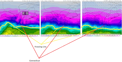
The NAM forecast model is the warmest of the guidance with the freezing line at 850mb (about 5,000 feet above the ground) already accelerating north through Connecticut by 7:00 AM EST Friday. The GFS and European models have this line in the vicinity of Long Island:
There are two key factors which will influence how much we warm between about 5,000 feet and 10,000 feet above the ground; in fact you can actually even say from the surface through about 10,000 feet:
1) There is a fairly stout, but small, high pressure system which will be positioned north of Maine and drifting off to the northeast. Clockwise flow around high pressure with high pressure in this position means a more north-northeasterly flow in the lowest few thousand feet of the atmosphere. This could inhibit warming within this layer, keeping temperatures below-freezing. Assuming temperatures warm above-freezing above this layer, this would have a significant impact on precipitation type with sleet vs. freezing rain and the precipitation type dependent on such factors as; the depth of the cold layer and how warm the warm layer is.
2) Forecast models track the main surface low right across New England with some indications a weak secondary low may develop south of Long Island. This is something which would work to lock in colder air at all levels of the atmosphere and would favor predominately snow, especially for far northern Connecticut.
It is very interesting to note, however, that forecast guidance; including the warmer NAM forecast model has continued to show colder evolutions throughout the day. This increases confidence in a much colder thermal profile across the state
Anyways, I don't really feel like going all crazy with the meteorology/science aspect (at least from a writing perspective...the work was done going into the forecast but I don't feel like translating it to a blog post). I'm actually not very thrilled with this threat...I hate sleet and I'm just ready for summer. So we're going to skip the science stuff and get into it.
What to Expect...
1) Precipitation begins moving into the state late Thursday evening (between 10:00 PM and 1:00 AM EST) and should begin as snow everywhere.
2) Snow should rather quickly become moderate-to-heavy at times. There may be a several-hour duration of moderate-to-heavy snow as forecast models advertise high-levels of vertical velocity across the state for a several-hour period.
3) The heaviest of the snow will occur between the hours of 4:00 AM and 10:00 AM Friday. During this window snowfall rates of 1-2'' per hour are likely.
4) Despite the colder profile, enough warming should occur towards the shoreline which should result in snow transition to predominately sleet. This will cut down significantly on snowfall totals, however, will transpire to significant travel hazards.
5) We will see very dangerous travel conditions for the Friday morning commute due to heavy snow falling inland and sleet along the shoreline. If you do not have to travel don't do so.
Below is what I am currently expecting:
