Sunday, January 20, 2013

Light to moderate snowfall possible across New England Monday night into Tuesday (1/21/13-1/22/13)

An area of low pressure will be developing across the mid-Atlantic states during the day tomorrow and then drift north/northeastward passing just to the east of the Cape/Islands.  Several computer forecast models are all developing an inverted trough or a "norlun" trough.  Typically we see troughs form and develop in a more northerly to southerly type fashion, however, the trough associated with the area of low pressure will actually be oriented in a easterly to westerly fashion.  This will allow for moisture associated with the area of low pressure to be thrown back westward into portions of central/southern New England.

  These norlun trough setups are always highly intriguing and make forecasting precipitation, in this case, snowfall very difficult b/c in the end it all comes down to mesoscale features and more often than not we really can't pin down the mesoscale features until the hours leading up to the event or in some cases not until the event has already gotten underway!  What we can, do however, is take a look at all the computer data available to us and sort of pinpoint an area of where these features may setup.

  The most important mesoscale feature in this case will be with regards to where any heavier bands of snowfall setup.  Given the model data we have it appears quite likely that any heavier bands of snowfall will setup out across far eastern MA and the Cape region with potentially another band of heavier snowfall across extreme northeastern MA extending into southwestern NH.  At this stage we also can't rule out portions of RI and eastern or SE CT getting into the heavier banding as well, however, this would depend on when the heaviest banding begins setting up and how much moisture the trough can throw back.

Thanks to an Arctic front that has been pushing eastward through the region during the afternoon the airmass ahead of this system will be extremely cold from the surface all the way up through the troposphere.  This will lead to some very impressive snowfall ratios, possibly in the order of 15:1 to 20:1 or perhaps even up near 25:1!  Given the high ratios we would be seeing this means we really don't need a great deal of moisture of precipitation to produce moderate amounts of snowfall accumulation as the snow will have a very high fluff factor.

Given with what the computer models have been signaling the past 24-hours this is what I think we should see for snowfall across the region.  Granted, we are still about 24-30 hours away from the onset of the system so we could still see major changes with regards to track/strength and how much moisture gets thrown back westward into the region.  Also, once we get to tomorrow afternoon or early evening we should have a much better handle on the mesoscale features and where the heaviest band or bands will setup and we will be able to fine tune where the axis of heaviest snowfall will be.  

Snowfall should start late Monday evening/early overnight and last through much of the AM hours on Tuesday, especially across eastern sections where light snows could last into the early afternoon hours.  Snowfall rates of 2-3'' per hour are possible, even some isolated 4'' per hour rates.  One interesting to watch out for will be the potential for thundersnow within the heaviest bands.  Computer models are suggesting we could see some elevated instability work into eastern sections of the region.  If we are able to generate thundersnow this would increase the potential for 4''/HR rates.


Tuesday, January 15, 2013

Light/moderate snowfall event Wednesday, January 16th, 2013

A weak area of low pressure sliding south and east of southern New England is expected to bring snow/sleet/freezing rain/rain to all of southern New England beginning during the early pre-dawn hours Wednesday morning.  What precipitation type or types your area receives will all determine where you are in relation to the system and we'll get into these details a little further down!

This storm system is not expected to be overly strong and produce significant snowfall amounts, however, given how the timing of the storm will be occurring during the AM rush hour this will make the morning communicate very difficult.  Expect a great deal of school delay's/closings.

Precipitation is going to begin breaking out between the hours of 2-5 AM with extreme southwestern southern New England getting into the action first and extreme northeastern southern New England getting into the action last.  It is also very possible that a few isolated pockets of precipitation occur across some locations even sooner than that.  Initially, with the exception of the immediate coastlines of CT/RI/SE MA, precipitation will begin as all snow.  Across the immediate coastline locations precipitation is expected to begin as a mix of rain/snow or perhaps even all rain.  Any snowfall across these areas should transition over to all rain rather quickly and snowfall totals should be less than a dusting and this is mainly on the grassy surfaces.  As we work through the early morning hours the rain/snow line should gradually begin working back towards the north and west as warmer air begins to work in both at the surface and in the lower levels of the troposphere.  This will line work northwest through eastern MA/RI/CT during the AM hours.  As this line works northwest we will begin to see many locations transition over to a period of sleet/freezing rain/rain and some places will eventually turn over to all rain as the system is winding down.  Areas across western/central MA and extreme northwestern CT are expected to remain all snow though a brief mix of sleet can't be ruled out.  One thing that we will have to watch out for will be a period of icing which will be possible if any locations can maintain a surface temperature in the lower 30's while temperatures aloft begin to warm.  Freezing rain is not expected to be a major issue but we could see a glaze of icing or perhaps maybe even an accumulation of around 1/10th of an inch.  This potential will be for the areas ending up right around the rain/snow line and will be highlighted with the map below.  Precipitation will begin winding down mid to late afternoon.

The area encircled in red is where the best likelihood of freezing rain/glazing has a chance of occurring.


Light/moderate snowfall event, Wednesday, January 16th, 2013

A weak wave of low pressure will be sliding just to the southeast of southern New England during the early AM hours of Wednesday.  As the wave of low pressure works close enough to the region we will see a period of precipitation with snow/sleet/freezing rain/rain all occurring across the region.  While this system is not expected to become all that strong there will be a small window where precipitation does fall rather heavily and this could lead to some isolated higher snowfall amounts.  Precipitation is expected to begin breaking out during the pre-dawn hours.  With the exception of the CT/RI/SE MA coasts precipitation is expected to begin as all snow.  As the morning hours go on and warming begins to occur both at the surface and through the lower levels of the atmosphere snowfall will gradually begin to transition to sleet/freezing rain/rain, especially across much of CT/RI and eastern MA.  The timeframe for heaviest precipitation should be from about 8 AM to about 1-2 PM in the afternoon before the precipitation begins to gradually slow down.


Thursday, January 3, 2013

Record warmth possible late next week?

Severe medium range/long range computer models have been hinting that as we move towards and into next week not only will our temperatures warm-up but we could be looking at a fairly significant warm-up, although it's unclear as to exactly how long the warm-up will last.  First we will take a look at the synoptic set-up being depicted by the models and then we will take a look at some global teleconnection forecasts and apply that to the forecasted synoptic pattern and figure out whether this all makes sense or not.

As we near the end of the weekend an area of high pressure will be developing across the southeastern United States and this will prompt a warm front to lift northward towards southern New England.  Models indicate that the warm front will push through likely during the day on Tuesday.  As the warm front inches closer to the region we will see a slow moderation of the temperatures and once the warm front passes temperatures will really escalate upwards.

At the same time a warm front will be lifting northward, out across the western United States a trough will be developing as a potent piece of shortwave energy digs into the desert southwest.  As this piece of energy continue to strengthen and sharpen the developing trough, the response to this will be to build a ridge into the eastern United States and slowly expand northward.  As this process occurs this will turn the wind direction from a more northerly direction (which we are seeing now) to a more south/southwesterly wind direction.  This will allow for a unseasonably warm low-level airmass to work well northward into southern New England by mid/late week.

Now that we have looked at the overall synoptic setup which is forecasted by several medium/long range forecast models we will now take a look at a few global teleconnections and then apply them to the synoptic pattern.

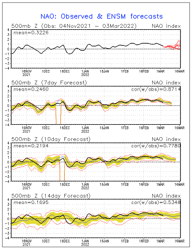
First off, we will take a look at the North Atlantic Oscillation (NAO).  During the winter months, the state of the NAO is one of the main players in determining how our weather will be.  The NAO is broken down into three different phases; positive, neutral, and negative.  The NAO is deemed positive when the Icelandic Low Pressure center is deeper than average and the Azores High Pressure center is also stronger than average.  This increased pressure gradient allows for a stronger jet stream across North America.  With the jet stream being stronger it's more difficult to generate deep troughs, therefore, the jet stream remains rather flat and further to the north, keeping the cold air bottled up in the Arctic or the other side of the globe and allowing for milder air to invade the United States.  The NAO is deemed negative when both the Icelandic Low Pressure and Azores High Pressure centers are weaker than average.  This leads to a decreased pressure gradient which weakens the jet stream allowing for greather potential of troughs to form which allow for colder air to be delivered into the United States.  The NAO is considered neutral when there is no clear signal or the the phase is too weak to have a major influence on the overall weather pattern.  Currently the NAO is slightly positive but the signal is weak so it's more in the neutral zone.  This is expected to change as we move through this weekend and into next week as model ensemble consensus is for the NAO to continue heading into the positive territory and even become quite positive:


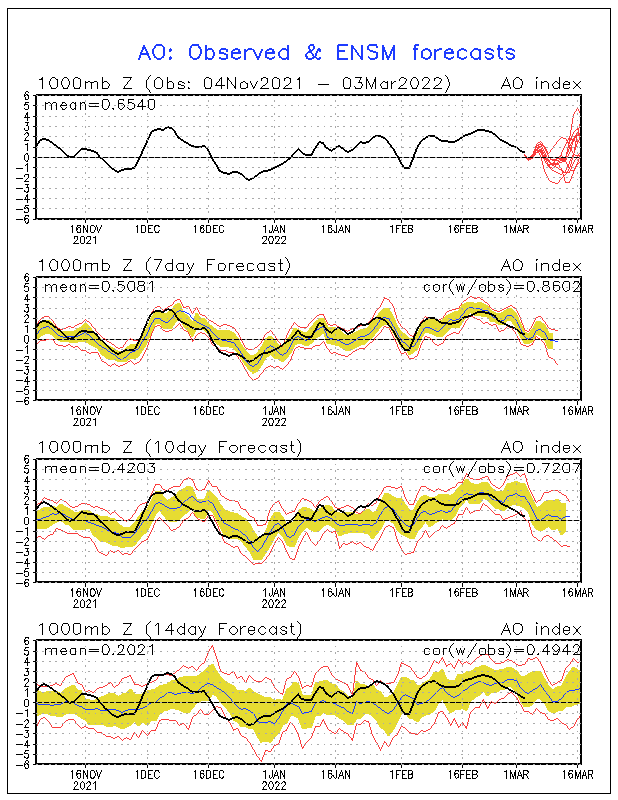
Secondly, we will take a look at the Arctic Oscillation (AO).  The AO sort of works in conjunction with the NAO and both are closely related.  Like the NAO, the AO is measured in three different phases; positive, negative, and neutral.  The AO is considered to be negative when geopotential heights over the Arctic region are well below-average leading to a much stronger than normal Polar vortex.  This leads to a stronger jet stream which inhibits colder Arctic Air from being transported further south into the United States.  during the negative phase of the AO, the geopotential heights are higher than average across the Arctic region.  This leads to a weaker than average Polar vortex which leads to a weaker jet stream allowing for colder air to be transported further south into the United States.  When the signal is not clear or weak, the AO is considered neutral.  Currently, the AO is more neutral, however, model ensembles forecasts are for the AO to quickly rise into positive territory and become quite positive, at least for a brief time:

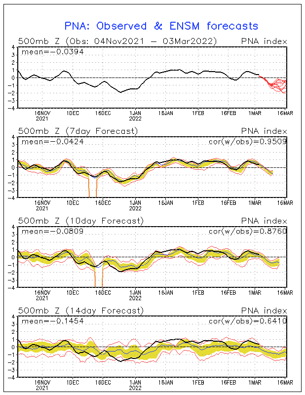
Thirdly, we will take a look at the Pacific North American pattern (PNA).  The PNA can actually play a significant role on the weather pattern across the United States, especially when the PNA signal is strong or when the NAO/AO signal is fairly weak.  The PNA is also measured as either being positive, negative, or neutral.  A positive PNA consists of above-average geopotential heights over the western United States (or a ridge) and below-average heights across the southeastern United States (or a trough).  This leads to above-average temperatures across the western United States with below-average temperatures across the southeastern and eastern United States.  During the negative PNA phase there are below-average heights across the western United States (or a trough) and above-average heights across the eastern/southeastern United States.  This leads to below-average temperatures across the western United States and above-average temperatures across the eastern/southeastern United States.  Currently, the PNA is quite positive, although computer ensemble forecasts indicate that the PNA will be quickly descending towards the negative phase by next week:

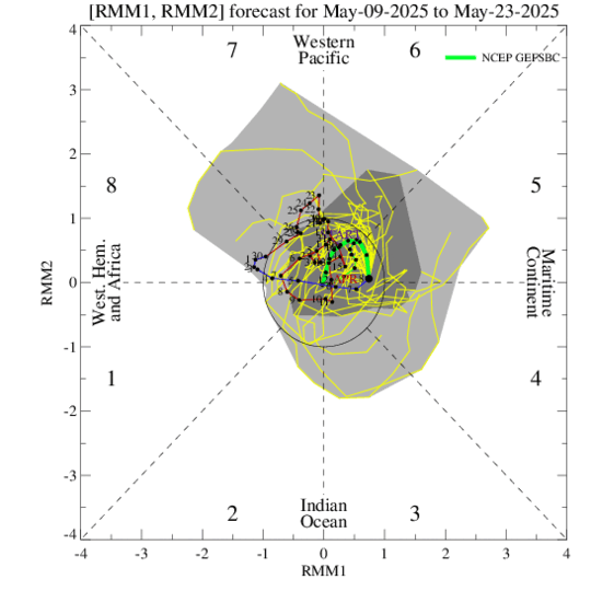
Finally, we will take a look at the progression of the Madden-Julian Oscillation (MJO) waves.  The MJO is a fluctuation of atmospheric pressures across the equatorial Indian Ocean and western Pacific ocean.  These MJO waves will traverse across the Pacific Ocean varying in different strengths and one major influence on the strength is the temperatures of the water they cross over.  MJO waves traverse along the equator in either a cyclonic or anticyclonic circulation.  During the cyclonic phase moisture is added to the MJO wave, enhancing convection/rainfall associated with the wave and during the anticyclonic phase the MJO wave suppress convection/rainfall associated with this wave.  MJO activity can play major roles in regions affected by the monsoon in both India and in the southwestern United States.  MJO waves can also greatly influence the weather pattern across the United States and temperatures.  The journey of the MJO is broken down into 8 different phases with each phase depending on the location of the MJO.  Between now and the 17th of January GFS ensemble forecasts have the MJO not only entering phases 4-6 but the potential for the MJO wave to be rather strong.  In reading the diagram below, the closer the "lines" to the center of the graph, the weaker the MJO wave and less of an influence on the weather pattern.  The further towards the borders of the chart, the stronger the wave.  Below is the diagram:
Phases 4-6 of the MJO are typically associated with temperatures above-average across much of the central/eastern United States and with below-average temperatures across the western United States.

Now we place all of this together.  When looking at the forecasted synoptic pattern by several medium-long range computer forecast models and looking at the projected trend in several key global teleconnections we can conclude that the upcoming period looks to not only be above-average across much of the eastern United States but the potential will exist for at least a few days with temperatures running well above-average.  The height of the warmth may occur in the Thursday-Sunday timeframe before a strong Arctic front looks to slide eastward.  It's possible we may be looking at record high temperatures for portions of the eastern United States and some locations could see temperatures running anywhere from +10F above-average to +2-F above-average.  

Following this period, it does appear we will see a transition towards more average or even below-average temperatures but other than that the signals are not very clear as to how exactly the pattern will evolve.  


Saturday, December 29, 2012

Snowfall forecast update

Now that the mesoscale features are becoming more clear and based on latest trends here is updated snowfall map:


Quick hitting storm system to bring snow to southern New England 12/29-12/30/12

An area of low pressure is currently working up the east coast and will be undergoing fairly rapid cyclogenesis over the next 12-18 hours.  This storm will have a solid amount of moisture associated with it, however, the storm will be a fast mover and the strongest lift will only be over the region for a brief amount of time.  Because of these two factors this will help to prevent this storm from dropping much more significant snowfall totals across the region.  If this storm were to move slower we could be looking at widespread amounts of 8''+ across much of the region.  

The storm will be tracking just to the south of southern New England and sliding northeastward towards the southeastern Canadian coastline.  This track will ensure cold air stays locked in place for pretty much the entire region meaning precipitation will be all snow.  It's possible, however, that locations along the CT/RI coastline and along the Cape begin as either a mix of rain/snow or a mix with sleet.  With this potential for mixing across these locations snowfall totals may be held back a bit.

Snowfall will begin breaking out anytime after noon-1 PM as snow flurries/showers ahead of the system move through the region.  While this will be a quick hitting system the height of the storm conditions will be very messy.  Snowfall rates of 1-2'' per hour are likely, perhaps even isolated 3''/HR rates where the strongest banding sets up.  The timeframe for the heaviest snowfall should be between 6 PM-12 AM.  This is when most of the accumulations will occur.  While snowfall will continue through the rest of the evening and overnight hours snowfall rates should be much more modest, below 1''/HR rates.  Snowfall will begin exiting the region from SW to NE beginning around 1-2 AM.

Winds may become a bit gusty as well across portions of the region, especially the southeast coast where winds could gust upwards of 25-35 mph.  While not significant this could lead to some isolated pockets of tree damage or perhaps power outages but this is not expected to be a significant issue.

Below is the forecasted snowfall map.  The area of 5-9'' is where the strongest lift/banding is expected to setup.  It's possible we could see some isolated amounts of 10'' somewhere within this area.  


Tuesday, December 25, 2012

Significant Storm to Impact New England 12/26/12-12/27/12

Currently there is an area of low pressure located across the Gulf coast states right around LA.  This area of low pressure has been slowly strengthening throughout the afternoon.  This system is already rather potent as it has been responsible for producing severe weather and tornadoes from eastern TX through LA/MS/AL and will continue to produce severe weather across these areas overnight as well as FL and then CS/NC/VA tomorrow as the system continues to deepen.

As the area of low pressure begins to track more northeastward following the spine of the Appalachian Mountains and the main piece of energy associated with the system strengthens we will begin to see a trough developing within the mid and upper level jet streams as depicted by the image below:


 When looking at the orientation of the developing trough we notice that the trough isn't developing in a north-south fashion but a more northwesterly to southeasterly fashion and looking at the image on the right we see a sharply negatively-tilted trough.  The combination of these two features means that there will be very little room for a storm track off-shore.  The rising heights will also allow for the winds in the middle and lower levels of the atmosphere out ahead of the system to shift more southerly and southeasterly.  With the system expected to undergo rapid cyclogenesis (strengthening) allowing for a rapid increase in the mid and low level wind fields this will allow for warmer air to quickly advect into portions of southern New England meaning many locations will see a quick transition from snow to sleet/freezing rain and then eventually rain.  Area to the north and west of the low pressure's center should pretty much remain all snow or see some mixing of sleet/freezing rain.  With this said the heaviest snowfall totals will be located across central/northern New England.

In addition to the mess of precipitation we will be dealing with this system is also expected to produce a period of strong/damaging winds, especially across the coastal areas of CT/RI/SE MA where a warmer low-level airmass will allow for better mixing of the lower atmosphere and where the wind fields will be much stronger.  There will be some very intense lift associated with this system as well so some rumbles of thunder certainly can't be ruled out either.

As usual with out winter storms this forecast will be very, very tricky as many of the thermal profiles, especially during the onset of the storm are very close to either being all snow or a mix of snow/sleet.  High temperatures tomorrow across the region are only expected to get into the mid-30's with dewpoints slowly creeping through the mid-20's.  As the onset of the precip shield starts progressing into the region evaporative cooling will 1) work to increase the moisture content of the atmosphere and 2) Allow for the surface temperatures to drop.  So essentially how warm the temperatures get tomorrow will play a big role in the precip type at the onset across many locations.  We then take a look at the thermal structure of the lower atmosphere.  Out ahead of the system we really don't have a great deal of cold air in place across our region or to our north.  Temperatures from about 925-700mb are only around -3C to -5C and there isn't any strong high pressure system to our north to allow for colder air to stay in place or drain down into our region.  This means that as the system continues to work towards the coast eventually warm air will overspread areas to the south and east of the storm's center allowing for a transition from snow-sleet-freezing rain-rain.  With this let's break down each aspect of the storm into further details and for each state:

Snowfall:

CT:

Precipitation is expected to first start working into CT between 1-3 PM with activity first occurring across the southwest corner of the state and spreading north and east through the remainder of the afternoon.  As of now, thermal profiles are rather tricky as several forecast soundings are very close to being either all snow or a mix of snow/sleet, especially across southern CT.  While surface temperatures are expected to range in the mid-30's or so temperatures aloft from 925-700mb are expected to range from -3C to -5C or so.  This really isn't all that impressive and should make for any snow that is falling to be rather wet.  This also poises difficulties with the forecast as if the precip is on the light side we could be looking more at more of a mixture.  Going with this I would expect everyone to begin as either snow or a mix of snow/sleet (with the mix more likely the closer to the coast you go).  As mentioned above the level of cold air in place isn't all that great and there is no high pressure to our north to reinforce colder air into the region.  We will begin to see warmer air work into the state rather quickly, especially across the coast and this will work to keep snowfall totals across the coast to a minimum and only about a few inches across the interior.  Some locations across the northwest corner of the state where cold air may hang in longer could pick up several inches of snow.  

RI:

Snowfall totals across RI should be kept to a minimum as well and accumulations are expected to remain under 1'' for the entire state.

MA:

As we work into MA this is where snowfall totals will begin to vastly increase, especially across the western and central portions of the state and outside of the CT River Valley in southern Hamden County.  Areas to the east of Worcester county in eastern MA are expected to receive little in the way of snowfall as warmer air will quickly work into these areas.  Areas to the west of Worcester County will have the potential to receive significant snowfall accumulations and snowfall could be on the wet side.  There will also be areas of sleet/freezing rain but we'll look at this hazard a bit further down.

NH/VT/ME

These states will be getting hit the hardest by snowfall accumulations as they will be to the north and west of the storm's center.  Snowfall accumulations here will be rather significant, however, b/c the aitrmass will be a touch colder snow should be more on the dry side.

Freezing rain/icing potential:

CT:

Some locations across interior CT could face a brief period of freezing rain between the transition of snow to rain.  As of now this hazard doesn't look to be a major issue, however, there could be a glaze of accumulation to perhaps just under a tenth of an inch of ice accretion.  With perhaps a few inches of wet snow accumulating, this could add a little extra weight to the snow allowing for the possibility of downed limbs or power lines.

MA:

There could be a corridor across central/southern MA where there is a several hour period of freezing rain, however, at this point it's tough to say if this will actually occur.  If this does occur the potential would exist for a few tenths of an inch of ice accretion.  With the potential for higher snowfall accumulations across these areas the risk for downed limbs/power lines would certainly be increased.  This will have to be watched as we get closer.

Rainfall:

For areas across southern CT/RI/eastern MA rainfall will be the main precipitation concern.  Rainfall totals of 1-2'' can be expected and this could lead to pockets of flash flooding/poor drainage flooding.

Strong/Damaging Winds:

With a very strong low-level jet working into the region we will be looking at a period of very strong winds, especially across southern CT/RI/SE MA where the core of the low-level jet will be located and where a warmer low-level airmass will lead to a little more in the way of mixing.  Across these areas winds will be sustained between 25-35 mph with wind gusts as high as 55 mph.  With heavy rains and a somewhat saturated ground this could lead to pockets of tree damage/power outages.  Elsewhere across the region winds should be sustained from 15-25 mph with wind gusts as high as 35-45 mph possible, especially across the higher elevations.

The height of the storm will be occurring during the overnight hours of Wednesday into Thursday lasting through mid-AM before the storm finally begins to taper down.  Below are graphics of what to expect: