Sunday, May 15, 2022

Monday, May 16, 2022 Northeast Thunderstorm Potential

 A shortwave trough is expected to move across the Northeast Monday with cold front moving through at the surface. As the cold front moves across the Northeast, a line of showers and thunderstorms is expected to organize across western New York and western Pennsylvania and propagate east-northeast through the region. 

Combination of temperatures climbing well into the 70's (with some localized lower 80's) and dewpoints pushing into the 60's will contribute to about 1,000-1,500 J/KG of MLCAPE. This will help aid in the development of showers and thunderstorms along with strengthening of this activity. Strong jet stream dynamics will also be present with 40-50 knots at 500mb and 35-50 knots at 700mb. This will help contribute to about 35-45 knots of vertical shear - plenty sufficient for storms to become organized.

Given the combination of a modestly unstable airmass and strong winds aloft, the potential will exist for the strongest thunderstorms to produce damaging wind gusts and hail. Forecast models also indicate increasing helicity through the day as stronger low-level winds at 850mb overspread the region so a brief tornado is also possible.

Noting the Storm Prediction Center has placed has placed much of New York and Pennsylvania in an enhanced risk (level 3/5) for severe thunderstorms with the greatest potential being damaging winds with widespread damaging wind gusts possible. This line is expected to rapidly weakening as it moves across southern New England as instability quickly begins to wane, however, localized wind damage will still be possible within the region. 

When assessing the potential environment to distinguish a more typical Northeast severe weather event versus a more substantial threat there are several red flags to note;

1) Weak mid level lapse rate - 700-500mb lapse rates are forecast to be on order of 5.5 - 6 C/KM. Weak lapse rates will put cap onto how much instability can materialize during the day as well as limit overall updraft (and subsequent) downdraft strength. 

2) The strongest of the low-level jet winds are confined to the 850mb level with winds forecast to strengthen to around 30-40 knots with a general 25-35 knots at 925mb. While these winds are rather adequate for these levels, they are a bit shy of what you would like to see for a higher magnitude damaging wind event. 

3) Questions regarding low-level lapse rates - The BIGGEST discriminator between more mundane and higher magnitude damaging wind events in the Northeast is low-level lapse rates. Stronger low-level lapse rates (> 8-8.5 C/KM) correlate much higher to widespread damaging wind potential. While these values may be achieved locally, there are questions about this on a widespread or region-wide level. 

Based on everything stated above, showers and thunderstorms rapidly develop by mid-to-late Monday morning across western New York and Pennsylvania and propagate east-northeast across the region with this line strengthening through the morning and early afternoon. Given the modestly unstable airmass and strong wind shear aloft, some strong-to-severe thunderstorms are likely with scattered damaging wind gusts, some hail, and the risk for a brief tornado. Given some of the uncertainties a more widespread damaging wind event doesn't appear likely, but there may be localized areas of more concentrated damage. 

(Note: Defining a higher magnitude damaging wind event - Several-plus reports of 65+ mph winds). 

Tuesday, March 8, 2022

Wednesday, March 9, 2022 Connecticut Snow Event

An area of low pressure moving off the mid-Atlantic and passing just south of Long Island results in a cute little snowfall event for Connecticut Wednesday. Snowfall accumulations are expected to be on the minor side given marginal boundary layer and surface temperatures with the greatest accumulations occurring across the northwest and northeast hills. 

As low pressure moves northeast off the mid-Atlantic coast passing just south of Long Island, the combination of a strengthening system, favorable upper-level dynamics to support large-scale lift, and a large temperature gradient across the region will yield the rapid blossoming of precipitation and snow across the state moving through Wednesday morning. Temperatures at 850mb (~5,000 feet above the ground) will be as warm as +10C to +12C just off the mid-Atlantic coast with 850mb temperatures as cold as -5C to -10C across New England resulting in a large temperature gradient which favors enhanced upward vertical motion. This will be further enhanced by a strong 150+ knot upper-level jet streak north of New England:


Forecast models also indicate we'll see some very strong frontogenesis move across the state Wednesday afternoon (evident by the red and spots of black below). This is important as this will help achieve heavier snowfall rates which will make accumulations more possible especially within the hills and road surfaces within the hills:


However, in order to maximize the heavier snowfall rates we'll have to get this lift to occur within the dendritic snow growth zone. This should be around 15,000 -20,000 feet Wednesday (slightly higher than what is preferred). Below is the 18z/08 NAM bufkit for New Haven, CT indicating the snow growth zone (yellow/purple contours) and omega (negative values or red contours indicate upward vertical motion...lift). Here we see omega values as low as -10 to -15 and even higher later in the afternoon:


What we're looking at for Wednesday is due to boundary layer temperatures which will be above-freezing and surface temperatures climbing into the mid-30's this will make snow difficult to stick to paved surfaces, especially when snowfall rates are on the light side. Under areas of much stronger lift when precipitation rates will be heavier, accumulations become more likely, especially on colder surfaces and now untreated surfaces. The depth of the warm-layer, however, is on the shallower side this is why despite the surface temperatures being in the mid-30's precipitation will be snow. A shallower warm-layer gives less time for melting. Also, temperatures as low as 1,000 feet off the ground are quite cold (~ -3C to -4C). This cold layer so low will help with the greatest accumulations occurring across the hills (elevations above 500 feet and especially above 800 feet). 

Below is what to expect:
  • Light snow breaks out across the state during the morning with areas and periods of moderate-to-heavy snow occurring at times.
  • Snowfall rates between 0.5''-1'' per hour under the heaviest band of snow and where snow rates are highest.
  • Timing for heaviest snow rates will be from late morning through late afternoon. 
  • Greatest accumulations within the northwest and northeast hills. Across lower elevations and the valley, majority of snow accumulations will be on grassy and untreated surfaces.
  • Significant travel disruptions aren't likely, but roads will be slick so give yourself extra time traveling. 


Wednesday, February 23, 2022

Friday, February 25, 2022 Connecticut Winter Storm

 A Southwest Flow Event (SWFE) or overrunning event is set to bring a wintry mess to the state of Connecticut. What is a SWFE or overrunning event? All this really means is the winds within the mid and upper levels of the atmosphere are coming from a southwesterly direction which typically transports warmer air which can overrun colder air locked in at the surface, hence, the term overrunning. 

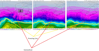
This is an extremely challenging forecast for Connecticut as it is a big battle between temperatures warming above-freezing between 5,000 and 10,000 feet above the ground and temperatures remaining below-freezing throughout the troposphere. This is the difference between significant snowfall accumulations (>8'') and lesser snowfall accumulations with more in the way of sleet.

The NAM forecast model is the warmest of the guidance with the freezing line at 850mb (about 5,000 feet above the ground) already accelerating north through Connecticut by 7:00 AM EST Friday. The GFS and European models have this line in the vicinity of Long Island:


There are two key factors which will influence how much we warm between about 5,000 feet and 10,000 feet above the ground; in fact you can actually even say from the surface through about 10,000 feet:

1) There is a fairly stout, but small, high pressure system which will be positioned north of Maine and drifting off to the northeast. Clockwise flow around high pressure with high pressure in this position means a more north-northeasterly flow in the lowest few thousand feet of the atmosphere. This could inhibit warming within this layer, keeping temperatures below-freezing. Assuming temperatures warm above-freezing above this layer, this would have a significant impact on precipitation type with sleet vs. freezing rain and the precipitation type dependent on such factors as; the depth of the cold layer and how warm the warm layer is. 

2) Forecast models track the main surface low right across New England with some indications a weak secondary low may develop south of Long Island. This is something which would work to lock in colder air at all levels of the atmosphere and would favor predominately snow, especially for far northern Connecticut. 

It is very interesting to note, however, that forecast guidance; including the warmer NAM forecast model has continued to show colder evolutions throughout the day. This increases confidence in a much colder thermal profile across the state

Anyways, I don't really feel like going all crazy with the meteorology/science aspect (at least from a writing perspective...the work was done going into the forecast but I don't feel like translating it to a blog post). I'm actually not very thrilled with this threat...I hate sleet and I'm just ready for summer. So we're going to skip the science stuff and get into it.

What to Expect...

1) Precipitation begins moving into the state late Thursday evening (between 10:00 PM and 1:00 AM EST) and should begin as snow everywhere. 

2) Snow should rather quickly become moderate-to-heavy at times. There may be a several-hour duration of moderate-to-heavy snow as forecast models advertise high-levels of vertical velocity across the state for a several-hour period. 

3) The heaviest of the snow will occur between the hours of 4:00 AM and 10:00 AM Friday. During this window snowfall rates of 1-2'' per hour are likely. 

4) Despite the colder profile, enough warming should occur towards the shoreline which should result in snow transition to predominately sleet. This will cut down significantly on snowfall totals, however, will transpire to significant travel hazards. 

5) We will see very dangerous travel conditions for the Friday morning commute due to heavy snow falling inland and sleet along the shoreline. If you do not have to travel don't do so. 

Below is what I am currently expecting:


Saturday, January 29, 2022

10:30 AM EST 01/29/2022 Connecticut Storm Update

Well it is time to declare my forecast a bust for a large portion of Connecticut. What led me to go with such an aggressive forecast for much of Connecticut was the idea that I believed we would see the low pressure (storm) end up with a more westward tracking putting Connecticut in line for some of the heaviest snow. 

Over the past 2-3 days, computer forecast model guidance continued to waiver and diverge between a more west and east track. Evolution of the mid and upper levels of the storm favored a more westward track, however, the evolution of the storm at the surface favored a more east track...so what was going to give? Unfortunately, there was really no way to full know this. So for forecasters, this left two options: 1) Be aggressive or 2) Be much less aggressive. There was no middle ground. The only way to know what would transpire was to watch the storm evolve in real time.

Latest mesoanalysis data shows the surface low pressure has consolidated on the eastward track (indicated by the red L and red arrow). This has resulted in the heaviest snows only getting into far eastern Connecticut. Connecticut is outlined in blue. The green arrow represents the track I thought we would see:


Eastern Massachusetts through Rhode Island and far eastern Connecticut are getting absolutely crushed with an extremely band of heavy snow and very strong winds as advertised by the radar below. This is where the highest snowfall totals will occur with totals likely exceeding 2 feet in the hardest hit places. 
For Connecticut, the highest totals will occur within the purple shaded area and these will include 2+ foot amounts. As you work west across Connecticut, snowfall totals will become significantly less. 


The gradient from west-to-east across the state will be wild. That is quite impressive for such a small state, but this just goes to show how slight deviations in a west/east track can mean substantial differences in snow totals! Whether you're getting slammed or a much more tame event, enjoy the storm!


Thursday, January 27, 2022

Saturday, January 29, 2022 Potentially Historic Winter Storm Update

 My confidence continues to increase that a potentially historic winter storm is set to unfold across Connecticut Saturday, January 29, 2022. This has been a very difficult 24+ hours in the world of weather models with various solutions ranging from near-historic impact to very little impact. However, given what I've assessed I am leaning towards the historic side of things. 

Regarding this potential storm, there were four key piece to monitor:

1. Shortwave energy within the northern branch of the jet stream

2. Shortwave energy within the southern branch of the jet stream 

3. Confluence associated with the tropospheric polar vortex in southeast Canada 

4. Ridging across the West Coast 


The biggest challenge these past few days has been the handling and evolution of each of the above-mentioned features by the computer forecast models. All (major) forecast models were in strong agreement that a significant storm was going to materialize off the East Coast, however, differences resulted regarding how the storm would evolve and where the storm would track. There were essentially two camps, a western track (closer to the coast) resulting in significant impact to Connecticut and an eastward track which would a much more mundane impact here in Connecticut, although eastern Connecticut may have been hit hard. 

My first forecast call was extremely aggressive which is very unlike me, however, I felt very confident in the westward solution. Since this forecast, some forecast models had thrown a "wrench" into that call by showing a farther east track. However, continuing to heavily assess and analyze how each forecast model was handling the above features, I remained very confident in the west solution. As we now move into Thursday evening, my confidence isn't only higher, but some of the forecast models with the east solution are now beginning to correct west. 

Given my expectation of a west track, this will result in a ferocious band of extremely heavy snowfall traversing a significant portion of Connecticut as evident by this exceptional frontogenesis band:

The 18z NAM bufkit at Windsor Locks, CT (BDL) was indicating as much as 30-40 units of omega (red contoured circles) which indicates extreme upward vertical motion within the dendritic snow growth zone (yellow/purple contours) which is the zone where the best snow crystals and growth occurs. This is also advertising snow ratios as high as ~17:1 (average is typically 8:1 to 10:1), however, the caveat here is the winds from the surface through the troposphere will be very strong and this will likely result in ratios potentially closer to 12:1 to 13:1:


These two above indicate the likelihood of extremely heavy snowfall for perhaps a 3-5 hour period. During this period snowfall rates of 3-5'' per hour will be likely along with the risk for some thunder and lightning given the degree of lift and some instability aloft! 

While the GFS forecast model is nowhere near as robust as the NAM or European forecast model, the strides within the features outlined at the start of this discussion make me confident the GFS will continue heading into the direction of the NAM/GFS. So let's get into storm impacts:

  • Heavy-to-extremely-heavy snow overspreads a large portion of the state moving through Saturday morning and continuing into late afternoon before gradually beginning to taper off. 
  • Under the heaviest banding snowfall rates could approach 3-5'' per hour!!!
  • Thundersnow possible.
  • Strong-to-damaging winds are expected statewide with sustained winds of 20-30 mph and wind gusts of 40-50 mph along the immediate shoreline. Sustained winds of 15-20 mph with gusts 30-40 mph inland. This will create blizzard conditions, significant drifting of snow, and extremely low visibility. (I have lowered my wind forecast from Wednesday's forecast).
  • Scattered power outages are likely, especially along the shoreline. Power outages may last a few days in some areas. 
  • Major coastal flooding along the immediate shoreline. 
  • Travel will be very dangerous and perhaps near impossible Saturday. due to the extreme snowfall rates, plow operators will not be able to keep up with the snow. While travel is highly not recommended, if having to travel, prepare a necessity kit in the event you become stuck or stranded.

Below is my updated forecast:


Wednesday, January 26, 2022

Significant Blizzard Shaping Up for Saturday, January 29, 2022

 Computer forecast models continue to show strong consistency and strong agreement that a significant blizzard is about to unfold across a large portion of southern New England and yes, this includes Connecticut. A low pressure system developing off the Southeast coast through the day Friday will undergo very rapid cyclogenesis (strengthening) as it works up the mid-Atlantic coast. The biggest question is/was exact track, however, this is starting to become more clear, but not yet set in stone so deviations in the track will result in deviations within the forecast. Adjustments will be made as needed. Note: Just because I am using output from a particular forecast model does NOT mean I am favoring that model or creating a forecast solely based on that model. The output is just used for illustrative purposes. 

Low pressure is expected to form right along the baroclinic zone Friday evening just off the Southeast coast. During this time an amplifying (strengthening) trough, southern stream shortwave energy, and strong upper-level jet dynamics will favor rapid cyclogenesis of the low pressure as it moves north-northeast just off the coast:


From this point, the one million dollar question is, how does northern stream shortwave energy interact with this system. This will play a substantial role in the evolution and overall track the low pressure system takes. There are some differences in this within forecast models. Some forecast models indicate a greater and earlier involvement of this northern stream shortwave energy, resulting in an earlier rapid strengthening and a closer to the coast track while some forecast models have this occurring a bit later, resulting in a slightly more east track. One of these models is the GFS forecast model. Given how close the baroclinic zone is to the Southeast coast, I believe the GFS is developing the surface low too far east and as a result, tracks the storm farther east (even though the interaction of the northern stream being later favors an already east track). 

Given the combination of upper-level dynamics and interaction of all pieces mentioned above, surface low pressure should strengthen incredibly rapidly as it moves north-northeast just off the mid-Atlantic coast, likely bringing major snow totals to portions of the mid-Atlantic. Forecast models are also indicating as much as 80+ knots of wind at 850mb (about 5,000 feet off the ground) feeding into the storm. This will result in copious amounts of moisture being fed into the storm:


As the low pressure system rapidly strengthens, low pressure centers develop at 850mb and 700mb (about 10,000 feet above the ground) indicating a very strong, mature system. Where these low pressure begin to develop, strengthen, and track are extremely important as historically, the bands of heaviest snowfall occur northwest of these low centers. In more developed lows this is about 30-50 miles northwest of the centers, in more poorly organized or just developing centers this can be as much as 60-70 miles northwest. This will also be tied into exact storm track, but the indication is this process will occur south and east of Connecticut and close enough to result in a band of extremely heavy snow traversing much of the state. The NAM forecast model (along with the European model) are very aggressive with this. The NAM in fact indicates an extremely powerful band of snow across the state 


Given the very cold airmass with this storm, snow ratios should be fairly high, perhaps on order of 18:1 to 20:1 (1'' of liquid would equal about 18-20'' of snow). Our average is about 8:1 to 10:1! This would be especially true under the band of heaviest snowfall where the degree of upward vertical motion into the dendritic snow growth zone would be maximized. The 12z/26 NAM bufkit for IJD (Willimantic, CT) indicates as much as 40-50 units of omega tapping into the dendritic snow growth zone (purple/yellow contours). That is incredible lift. This would indicate the potential for snowfall rates of...3-5'' per hour!!!! along with the potential for thundersnow:


With such an intense low pressure not far off to the southeast, this will translate to very strong winds thanks to a very strong pressure gradient. Winds along the shoreline could become sustained as high as 25-35 mph with gusts 60-70 mph. Winds just inland could become sustained as high as 15-25 mph with gusts 40-60 mph. 12z NAM/26 bufkit for Groton, CT shows very high wind potential. This would result in blizzard conditions, significant drifting of snow, very low visibility, and scattered-to-numerous power outages:


So with the meteorology/science fun out of the way let's break the storm impacts and timeline down:

What to Expect: 

  • Light snow showers throughout the day Friday. 
  • Light snow may develop during the evening and overnight well ahead of the storm. This snow will have potential to produce 1-3'' of snow locally. 
  • Saturday...
    • Heavy-to-extremely-heavy snow overspreads a large portion of the state moving through Saturday morning and continuing into late afternoon before gradually beginning to taper off. 
    • Under the heaviest banding snowfall rates could approach 3-5'' per hour!!!
    • Thundersnow possible.
    • Strong-to-damaging winds are expected statewide with sustained winds of 25-35 mph and wind gusts of 60-70+ mph along the immediate shoreline. Sustained winds of 15-25 mph with gusts 40-60 mph inland. This will create blizzard conditions, significant drifting of snow, and extremely low visibility. 
    • Scattered-to-numerous power outages are likely, especially along the shoreline. Power outages may last a few days in some areas. 
    • Major-to-devastating coastal flooding along the immediate shoreline. 
    • Travel will be very dangerous and perhaps near impossible Saturday. due to the extreme snowfall rates, plow operators will not be able to keep up with the snow. While travel is highly not recommended, if having to travel, prepare a necessity kit in the event you become stuck or stranded.

Below is my initial snowfall forecast. Please keep in mind, given the high uncertainty and low predictability which exists with determining where the heaviest banding will set up and traverse, it's very difficult to highlight that on a map right now. Also, anytime you see such an intense band of heavy snow you get an area of subsidence (sinking air) this will result in less totals in areas under subsidence and that is also very difficult to illustrate on a map. As we get closer, these details can be ironed out:


Monday, January 24, 2022

Prospects for a Significant Winter Storm Increasing (Saturday, January 29, 2022)

Computer forecast models continue to come into strong agreement (with consistency) that a significant storm will evolve moving into the upcoming weekend. After a challenging past few winters in the forecasting department which makes me skeptical about raising awareness for storms several-days out, the evolution of the pattern and pieces involved give me enough confidence to communicate the idea of a rather significant storm. The past few winters have been characterized by a rather fast jet stream with many embedded pieces of shortwave energy. This results in chaos and high model uncertainty as more pieces involved, the longer (and more challenging) it takes for forecast models to resolve. A comparable example is that of a puzzle. If you're doing a puzzle which is only 50-pieces, you have less pieces to work with and it's going to be easier to (re)solve the puzzle. However, if you have a puzzle that's 500-pieces or 1,000-pieces, you have more pieces to resolve and it will take longer to complete. 

For the upcoming potential this weekend, there are really two MAIN pieces of shortwave energy we're watching. (Note: While I am using GFS model output in below images this does NOT mean I am favoring the GFS or forecasting solely off the GFS. I am just using for illustrative purposes).

As we progress through the week a large ridge of high pressure builds into the western United States with a vigorous trough amplifies (strengthens) across the eastern-third of the United States. Forecast models indicate a piece of shortwave energy traverses the eastern periphery of the ridge with this shortwave energy (becoming associated with the southern branch of the jet stream) amplifying as it digs into the Gulf Coast states (shortwave #1). Moving towards the end of the week, forecast models indicate shortwave energy diving through the upper-Great Lakes region in association with the northern branch of the jet stream (shortwave #2):


Forecast models indicate a positively-tilted trough (with the trough axis digging into Mississippi/Georgia) becoming more neutrally-tilted to slightly negatively-tiled  as it traverses the southeast. This is a very favorable scenario for rapid low pressure development just off the southeast coast and also favors a storm track closer to the coast. Shortwave #2 is very important here because depending on the interaction, shortwave 2 can further enhance rapid development and it can act as a means to keep this storm closer to the coast as well:


In addition to these two pieces of shortwave energy the evolution and structure of the ridge within the West may have huge implications, especially with how the trough evolves in the East. A stronger ridge could result in the trough axis shifting east a bit increasing the likelihood of a farther west track (coast or just inland) while a bit weaker or more flat ridge could push the trough axis east, increasing the potential for a track off the coast. In this scenario, phasing of the two shortwaves will be huge as this could open the window for a missed phase and storm track well off the coast. At this stage that is appearing more unlikely. 

As low pressure develops and moves up the coast (this is a big vague here as the exact track is far from certain. Up the coast in this sense means anywhere from just inland to anywhere just offshore enough to still bring impacts inland) rapid cyclogenesis (deepening) is expected thanks to incredibly favorable upper-level dynamics. Forecast models indicate a powerful 150+ knot upper-level jet streak may transpire across northern New England moving into Saturday. This jet stream structure and jet streak would favor tremendous upper-level divergence over the Northeast into the mid-Atlantic with the result being rapid deepening of the ow pressure and blossoming of precipitation:


Forecast model ensembles (as well as operational runs) are suggesting storm tracks and potential for favorable evolution which would bring significant storm impacts. This includes extremely heavy snowfall and significant totals, high winds with the risk for power outages, rain along immediate coastal areas (particularly eastern Massachusetts), and devastating coastal flooding. Below is the 12z European Forecast Model Ensemble with each "L" (Low Pressure) the forecast of a specific model-member. At this stage, there is strong agreement in a track very close to the benchmark and that historically can result in very heavy snows for much of Connecticut:


Depending on exact storm track and evolution, there will likely be a very step temperature gradient established between warmer east east of the storm and colder air west of the storm. This will likely favor a corridor of extremely heavy upward vertical motion and subsequent heft precipitation rates. This will occur perhaps 50-75 miles northwest of the surface, 850mb, and 700mb low tracks. One second area to watch (more so getting into eastern Massachusetts) will be a very strong surface temperature gradient where the coastal front sets up. That boundary will be the difference between zero snow and perhaps quite a bit.

Given we are 4-5 days out it is impossible to get into specifics and details such as exact storm track, exact storm evolution (where the 850mb and 700mb lows develop, track, and how they evolve), and potential amounts. However, at this juncture, based on the signals, the potential is rapidly growing for a very significant storm. 

An updated blog post will come forth early Tuesday evening. This will provide a storm update along with getting into a bit more of the specifics (positives and negatives).